If you are on an older version and under maintenance coverage then you qualify to upgrade for free to the latest version of our software. (Consult your RMS Integrator for correct versioning). If you are out of maintenance coverage, please contact our Sales Group.
Please note, Version 4 and 5 of all products have reached their End of Life. Please contact our Sales Group for upgrade options.
Version 7.7
-
The terminology used to describe changing the current view of a symbol to top, bottom, side, etc. is now "Change Orientation".
- A "Change Orientation" command has been added to the tool bar.
-
When a symbol is selected, the key combination ALT-O toggles symbol orientation.
-
The default location for text in vehicle symbols has been changed from the center to beneath the symbol to improve visibility.
-
Symbol Additions and Improvements:
- Front and rear view have been added for commonly used vehicle symbols.
- New top-down view pedestrian symbols have been added.
- New recreational vehicle symbols - boats, ATVs, jet skis, and associated trailers have been added.
- New electric and motor scooter symbols have been added.
- New motorcycle and bike helmet symbols have been added.
- New school crossing sign symbols have been added.
- New triangle warning lane marker symbols have been added.
- The North Indicator symbol now has thicker lines to enhance visibility.
-
The selection of regional settings including language, measurement systems and appropriate symbols has been simplified.
-
Explicit support for licensing in virtualized environments has been added.
-
A link to the fingertap.com documentation web site has been added to the help menu in all products.
Version 7.6
General:
-
NearMap is now available as an additional map image source in diagrams.
This provides customer with another source of high-resolution map imagery.

-
Symbols search has been improved by considering symbol categories and by improving the ordering of symbol search results.
-
Symbols are now organized by region and region-specific symbols can be enabled and disabled.

-
Symbol Additions and Improvements.
Many new symbols have been added including scooters, helmets, additional school crossing signs, recreational boats and items related to wildlife conservation.
-
Diagram printing has been improved by updating available pages sizes to better support the needs of European customers and by adding full support for FireFox.
-
Crosswalk formatting has been enhanced to include more control over stripe color and the layout of stripes.
Version 7.5
General:
-
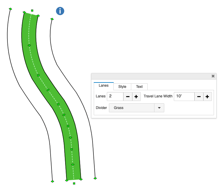
Grass Divider & Lane Coloring
A new grass street divider type has been added. Street lanes may also have a fill color.
-
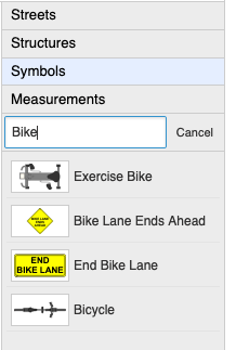
Symbol Search
Symbol search has been improved by considering additional symbol keyword metadata. This makes it easier to find symbols using alternative names. For example, searches for "Bike" and "Bicycle" will both include the bicycle symbol.
-
Auto-Numbered Label Symbols
New auto-numbered label symbols are now available. These symbols are automatically assigned a unique number as they are added to the diagram. They are available on the streets, structures, and symbols layers.

-
Linear Symbol Profiles
The profile of linear symbols can be set in the same way as streets and lines.
Desktop:
- The commands available for diagram and views in the form and form navigator are more consistent. Diagrams can now be added and deleted from the form navigator as well as from the form.
Web SDK:
- A new API method has been added that destroys the diagram editor. This is useful when the editor must be created and destroyed more than once during the life of a page.
- Group and un-group accelerator keys have been added that are consistent with our Windows apps. I.E., CTRL-G will group symbols and CTRL-U will un-group symbols.
ESD Editor:
-
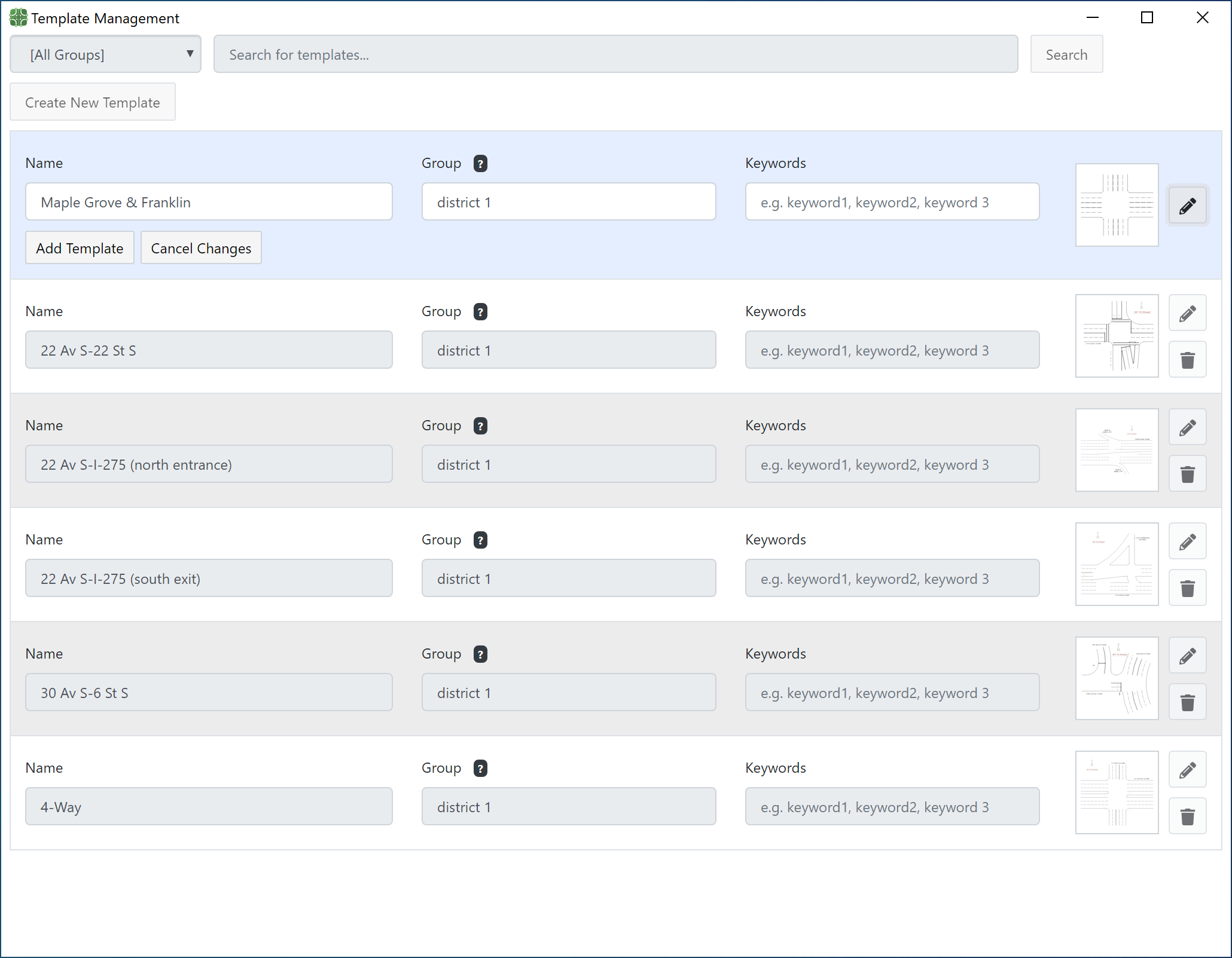
New Template Manager
A new templates management facility has been added. This tool allows users to create, update, and delete templates in the ESD Editor.
-
Casebook Management API
A new casebook management API has been added. This API enables the creation and processing of documents that contain multiple diagrams.
-
Group & Ungroup Hot Keys
Group and un-group accelerator keys have been added that are consistent with our Windows apps. I.E., CTRL-G will group symbols and CTRL-U will un-group symbols.
Version 7.4
General:
-
New Street Drawing Tools
New tools have been added for free-hand drawing of curved road segments. Tools have also been added for drawing roundabouts and closed street segments. The following diagram was created using these new tools:
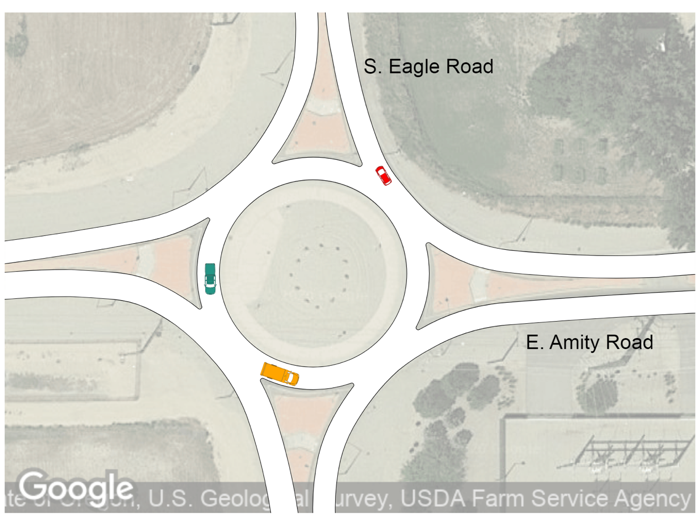 Intersection with a Roundabout and Curved Streets Drawn Using ScenePD Web V7.
 -
Overpasses
Overlapping street areas can now be shown as your choice of an intersection or overpass.
-
Structure Drawing
Drawing of off-angle structures has been improved with additional visual aids. When walls are added to a structure, they automatically adjust to the structure’s orientation. We have added drawing aides that help users easily set the positions of walls, windows, and doors precisely. Structure drawing has also been moved to a separate layer to make it easy to create diagrams that contain streets, structures, and symbols (in versions 4, 5 and 6 structures and streets were on one layer).
-
Structure Dimension Output
The way structure dimensions are printed and exported can now be controlled separately for each structure in a diagram or casebook. In the past this was an application-wide option. The following image shows three structures with different dimension output settings.

-
Views
Multiple rectangular regions that can now be defined within each diagram. These regions (views) behave like virtual diagrams. They can be selected, printed, exported as an image, or set as the final diagram result. Views are also incorporated into casebooks along with diagrams. They are displayed, printed, and exported along with other casebook content. The images below show a complex diagram and a view of a small area of the same diagram:
 A Complex Street Diagram with View Area.
 A View of the Diagram Shown in Image 7.
 -
Mapping
The mapping feature has been redesigned. Bing, Google, ESRI base maps, and internal ESRI servers are supported. All map images are automatically updated when diagrams are resized, panned, or zoomed. Map images remain underneath all other diagram layers and they can be selectively dimmed.
-
Diagram Printing
A diagram can be printed on multiple pages, with a specific page size and orientation. Measurement data can optionally be included with diagram printouts.
-
X-Y Measurements
A new measurement type, X-Y Measurements, has been added. X-Y Measurements are points defined by a horizontal (X) and vertical (Y) offset from a reference point. X-Y Measurements can be entered manually or imported from a CSV file.
-
Image Scaling
Images imported into diagrams can be easily scaled to match the measurements in the diagram.
-
Image Cropping
Images imported into diagrams can be cropped to eliminate unneeded content.
-
Licensing
Our licensing processes have been changed to support subscriptions as well as traditional perpetual licenses.